For over 20 years, we have been developing integrated solutions that enable us to support our clients in seizing the opportunities offered by smart mobility and digital transformation. Thanks to an innovative approach based on Artificial Intelligence, we have developed advanced algorithms for accident detection, driving behavior analysis, claims management, and consumption optimization
Year: 2022
Shared Mobility in Rural Contexts

Researchers Åsa Hult and Lisa Perjo from the Sustainable Society Unit, IVL Swedish Environmental Research Institute, Sweden, and Göran Smith from the Mobility and Systems, RISE Research Institutes of, Sweden (also from Department of Regional Development, Region Västra Götaland, Sweden and Institute of Transport and Logistics Studies, University of Sydney, Australia), published an article in Sustainability on 10 September 2021, regarding shared mobility in rural contexts. The article provides an a-up to date review on this issue. Here there are some of the key issues.
Rural contexts are characterized by low population densities and long distances between societal functions such as schools, shops, and healthcare facilities. These characteristics make it difficult for public transport authorities (PTAs) to provide a level of service that is both satisfactory for rural dwellers and financially reasonable for taxpayers. Consequently, rural populations are oftentimes more dependent on car travel. For instance, according to the most recent national travel behavior survey in Sweden, people in small towns and rural municipalities use cars for about 76% of their daily traveled kilometers, while the corresponding number for people in large cities and in municipalities near large cities is 48%.
One consequence of the high car dependency within rural transport systems is that many are forced into car ownership. In other words, many rural dwellers own and use cars even though they would rather not. However, since cars are expensive and require physical and cognitive abilities, this option is not available for all, especially not for children, the elderly, and people with disabilities.
Thus, the study establish that although the share of the population that is exposed to car deprivation in rural areas is lower than in cities, the perceived consequences for those who cannot get access to or drive cars are more severe; transport poverty is more likely to be a source of social exclusion on the countryside.
The Problem: Transport Poverty in Rural Areas
Transport poverty is a broad, overarching notion that encompasses mobility poverty (lack of transport options), accessibility poverty (difficulty of reaching certain key activities), transport affordability (lack of resources to afford available transport options), and exposure to negative transport externalities. Hence, an individual can be said to be transport poor if at least one of the following conditions apply:
- There is no transport option available suited to the individual’s physical condition and capabilities
- The available options do not reach destinations where the individual can fulfil daily activity needs
- The money spent on transport leaves the household with a residual income below the poverty line
- The individual needs to spend an excessive amount of time travelling to fulfil daily activity needs
- The travel conditions are dangerous, unsafe, or unhealthy for the individual
The Proposed Solution: Mobility as a Service
“The vision is to see the whole transport sector as a cooperative, interconnected ecosystem, providing services reflecting the needs of customers and seamlessly combining different transport means, such as private vehicles, public and collective transport (bus, metro, light rail, car sharing), biking and walking”. In practice, this means offering a new digital service layer, which provides users with a single point of access for finding, booking, and paying for mobility services.
Although MaaS arguably still mostly exists in PowerPoint presentations and strategy documents, a few services are available to the public, especially in European cities. These include Jelbi in Berlin (jelbi.de), Whim in Helsinki, and Yumuv in Zürich, Basel, and Bern. However, pilot projects excluded, there are few examples of MaaS services that address the travel needs of rural dwellers.
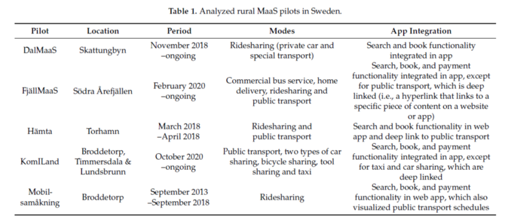
The analysis in the article covers pilots of shared mobility and MaaS in rural areas of Sweden.
Future Roles and Activities
There were different opinions among the interviewees on how mobility services must develop to meet the needs of rural dwellers. Accordingly, their views diverged on what roles different actors should take in the future rural mobility landscape as well as on what actions needed to be taken to get to the envisioned state. The solutions to improve accessibility in rural areas, most frequently brought up by the interviewees, were to enhance the on-demand offering and to complement traditional public traffic with new types of mobility services. Still, some of the involved actors questioned whether one can expect a high service level in all types of areas.
The researcher stress that regardless of the PTAs’ role, there was a strong agreement among the interviewees that involvement of residents in the development and operation is key; an actionable and influential local civic organization was seen as a prerequisite for the adoption and diffusion of new types of mobility services, especially of those that require a certain level of penetration to function well, such as ridesharing.
Accordingly, the civic organizations saw themselves as the ambassadors of rural MaaS towards the residents as well as the actor that can make sure that the services meet the residents’ needs. Hence, it was argued that local civic organizations should be involved to a high degree already in the design phase.
Comparably, the commercial mobility service providers argued that they possess the most knowledge about mobility services, and therefore should be involved at an early stage as well. This would enable them to take part in the design of the service rather than only providing the requested services, which in turn would lead to better services, they argued. Several interviewees emphasized the important role of municipalities in rural MaaS.
Discussion
Both rural and urban MaaS are framed as solutions that aim to complement public transport and to reduce the perceived need of owning and using private cars. However, while this motive is grounded in problems such as road congestion, poor air quality, unhealthy travel choices, and greenhouse gas emissions when discussed for the urban context, the analyzed pilots were primarily motivated by the need to better provide access to rural dwellers, especially to people that either have limited or no access to private cars or people that want to reduce their private car dependency for other reasons. To put it simply, the interviewees’ focus was less on environmental sustainability and more on transport poverty.
In rural areas, the potential base of users is small, which makes services that require a critical mass to function well, such as ridesharing, vulnerable to external disturbances like changes in peoples’ everyday life, the interviewees argued.
This vulnerability was also, in some cases, linked to a high share of elderly residents who were less technology savvy. Other reasons for the limited activity in the pilots, proposed by the interviewees, included travel habits that are difficult to break, insufficient incentives to use the mobility services, limitations to the trialed systems and apps and therefore large entrance barriers for users, and uncertainty about roles and a lack of a culture of innovation within the involved organizations that led to low-value service offerings being trialed in the pilots. Hence, the actors involved in the studied pilots seem to have faced similar barriers as their urban counterparts.
Rural public transport has decreased in many places over the last decades due to a combination of factors including urbanization and austerity measures. Consequently, the levels of private car ownership, car traveling, and car dependency are typically higher in rural areas compared to the urban context. The article concludes that since car ownership and habitual car use are two of the greatest barriers to MaaS adoption, it follows that rural MaaS faces even greater challenges than urban MaaS.
Hence the authors understand that even though the analyzed pilots neither prove nor disprove the potential for rural MaaS, it can be assumed that the introduction of MaaS will not mitigate rural transport problems on its own. The study understands that to break car dependency and improve accessibility for non-car owners in rural areas, alterations that fundamentally change the context of rural traveling will be needed as well.
As argued within the literature on sustainability transitions, and recently exemplified by the COVID-19 pandemic, fundamental transformations of practices within socio-technical systems (such as personal transport) are more often than not caused by a combination of mutually reinforcing global events (such as the spread of the virus), change processes at system level (such as the travel restrictions and working from home policies that were mposed in the wake of the virus), and break-throughs of promising technology alternatives (such as telecommuting services).
Conclusions
The interviewees, more or less unanimously, stressed that rural MaaS must build on local needs and that local residents therefore should be involved in the design of the services. In particular, representatives of technology providers and local organizations emphasized a need for so-called place-based solutions, instead of one-size-fits-all solutions developed at a municipal, regional, or national level. All in all, anchoring with and involving locals seem to be essential components for rural MaaS developments no matter who the initiator is, in particular, to make sure that the services address real user needs and to put the services in position to attract sustained usage.
The researchers stress that rural dwellers are more willing than urbanites to actively participate in MaaS operations and to share private resources. Measures may need to be taken to ensure equal opportunities across rural communities when developing and disseminating rural MaaS. One of the conclusions of the article is that future research should, for example, explore how rural MaaS solutions can be co-created with residents in rural communities with less social capital.
The limited activity in the five analyzed pilots indicates that more research is needed into how one can motivate potential users to adopt and use rural MaaS solutions. The study underlines that future studies on rural MaaS users should, investigate who benefits from rural MaaS developments, and who does not. For instance, the reported analysis identified a risk that rural MaaS solutions might increase spatial injustice between rural communities. This risk should be further analyzed.
Additionally, the authors emphasize that future studies should investigate rural MaaS solutions’ potential to either alleviate or worsen transport injustice along other dimensions, such as age, gender, socioeconomic status, or ethnicity.
Auto Insurance Report National Conference
OCTO is to participate at the “Auto Insurance Report National Conference”, which takes place in Dana Point – California, from 24 to 26 April 2022.
This is the single most valuable event for the auto insurance industry. Virtually every active auto insurer will be in attendance, along with all the leading providers of data and professional services.
OCTO’s Christina Presnar will be attending the “Auto Insurance Report National Conference”.
Don’t miss the opportunity to join us!
I pilot di riferimento per lo sviluppo della “Via italiana alla mobilità connessa”: una mappatura di oltre 160 casi
Durante l’edizione 2021 dello sviluppo della “Via italiana alla mobilità connessa”, OCTO Telematics e The European House – Ambrosetti hanno identificato oltre 35 progetti pilota di cui 14 considerati prioritari, definiti “quick win”, ovvero implementabili in un periodo di circa 6 mesi. I progetti pilota, che puntano alla concretizzazione della Vision Zero di OCTO, spaziano all’interno di 4 aree strategiche – “Smart e Connected mobility come abilitatori per la Smart City”, “Mobility-as-a-Service” (MaaS), “Mobilità connessa e gestione delle flotte” e “Ecosistemi e spazi dati per la co-creazione di servizi”.
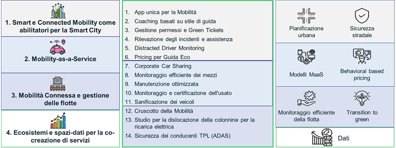
Figura 1 Articolazione delle aree strategiche per progetti pilota e per macro-contenuti. Fonte: elaborazione The European House – Ambrosetti e OCTO Telematics, 2022
L’edizione 2022 del programma si è posto l’obiettivo di concretizzare i progetti pilota creando relazioni tra i diversi stakeholder e promuovendo la nascita di un ecosistema di attori legato alla mobilità connessa. Questo primo articolo intende fornire una panoramica dei case study più rilevanti nel contesto italiano e globale, con una triplice finalità:
- creare un benchmark di riferimenti a livello nazionale e internazionale circa lo sviluppo di progetti relativi alla mobilità connessa per trarre spunto dai progetti che si sono contraddistinti per il loro grado di innovazione o per la loro capacità di coinvolgere molteplici stakeholder;
- comprendere le specificità e i punti chiave legati alle singole aree strategiche;
- individuare gap di mercato da colmare, come i progetti pilota meno implementati o nuove città in cui intervenire.
Grazie a un’intensa attività di ricerca, sono stati mappati 160 casi, di cui 92 in Europa (10 in Italia), 24 in USA e 13 in Cina.
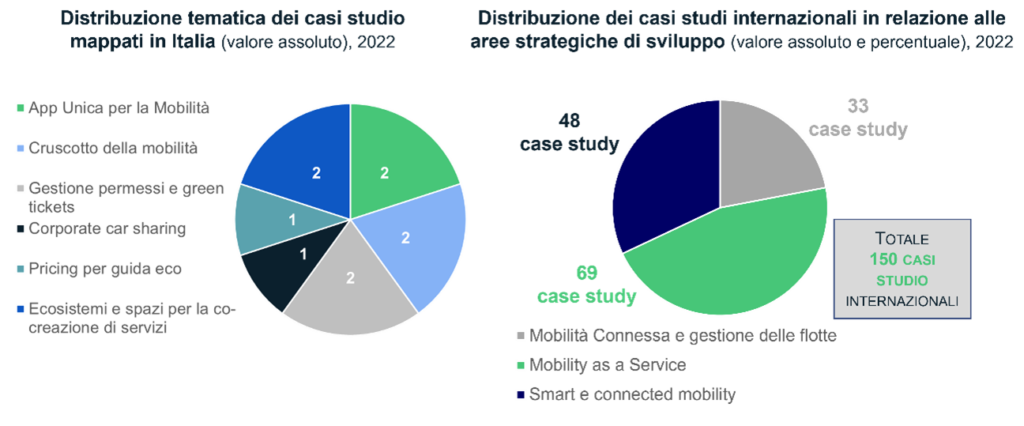
Figura 1 Distribuzione tematica dei casi studio mappati in Italia (immagine di sinistra) e a livello internazionale (immagine di destra), valore assoluto e percentuale, 2022. Fonte: elaborazione The European House – Ambrosetti, 2022
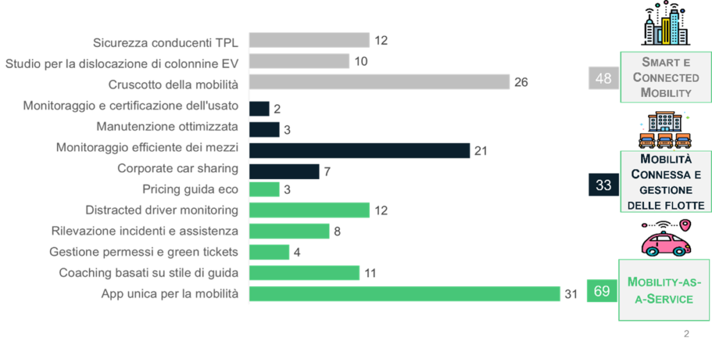
Figura 2 Numero complessivo di casi studio a livello internazionale analizzati per progetto pilota, valore assoluto, 2022. Fonte: elaborazione The European House – Ambrosetti, 2022
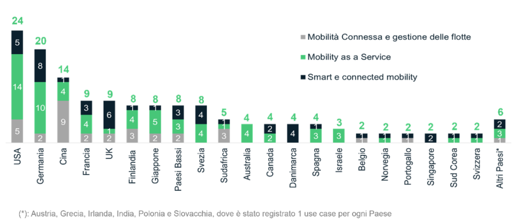
Figura 3 Distribuzione geografica dei casi studio mappati a livello internazionale valore assoluto, 2022. Fonte: elaborazione The European House – Ambrosetti, 2022
Per quanto concerne l’area “Smart e Connected Mobility”, sono stati individuati 2 progetti a tema “Cruscotto della Mobilità” in Italia e 33 su scala globale – questa area comprende complessivamente il 22% del totale use case mappati. Analogamente al contesto italiano, anche a livello internazionale i pilot “Cruscotto della Mobilità” sono i più diffusi (17,3% – 26 casi). I punti chiave emersi sono riassunti nella figura che segue.
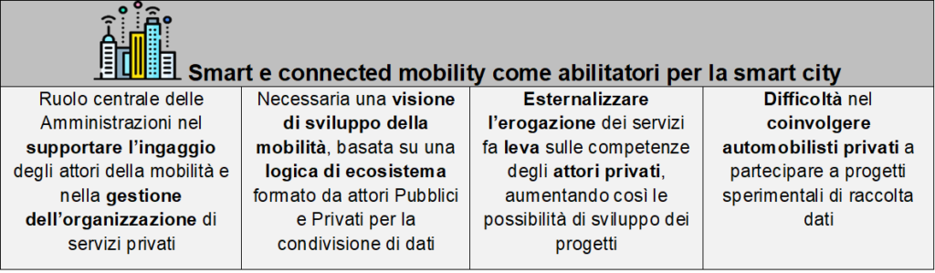
Figura 4 Temi chiave dell’ambito “Smart e Connected Mobility come abilitatori per la Smart City”. Fonte: elaborazione The European House – Ambrosetti su dati vari, 2022
Per avere un riferimento circa l’implementazione dei progetti pilota in quest’area, di seguito sono riportati un caso italiano e uno internazionale.
5T Torino è una società in-house a totale partecipazione pubblica per la progettazione, realizzazione e gestione di sistemi e servizi per la Centrale della mobilità e dell’infomobilità di Torino e del Piemonte. L’obiettivo è creare nuovi modelli di servizio e di paradigmi tecnologici per rispondere ai bisogni in continua evoluzione degli utenti. È stato sviluppato un ecosistema per la creazione di centrali della mobilità di Torino e del Piemonte e sistemi MaaS, utilizzando tecnologie digitali e sistemi IoT integrati nelle infrastrutture cittadine esistenti e di nuova costruzione. Ad oggi, sono stati “centralizzati” 300 incroci per controllare il traffico, sono stati installati 1.000 sensori per la misurazione dei flussi di traffico, 71 telecamere di monitoraggio, 43 varchi di ingresso all’interno della ZTL e 25 pannelli di infotraffico.[1]
Analizzando i casi internazionali, è emerso un interessante esempio di “Sicurezza dei conducenti TPL” realizzato dalla cinese Roadefend Vision Technology (azienda specializzata in sistemi ADAS e gestione Big Data connessi) in partnership con Alibaba. Il progetto nasce per aumentare la sicurezza dei conducenti grazie ad active safety systems (telecamere, sensori) installati a bordo, in grado di immagazzinare in cloud le informazioni raccolte per alimentare algoritmi di artificial intelligence in grado di generare segnali di allarme in caso di rischio. La soluzione Roadefend sfrutta una tecnologia avanzata di analisi di immagini ad alta risoluzione per il monitoraggio “esterno” (ad es. condizioni metereologiche e di prossimità ad altri veicoli/ostacoli) e “interno” (ad es. mimica facciale del conducente per rilevare segnali di distrazione o stanchezza). Inoltre, è stata creata una piattaforma cloud dove sono riportati in tempo reale i dati di guida raccolti tramite GPS, visualizzabili in una dashboard in continuo aggiornamento. Ad oggi, i dispositivi Roadefend sono stati installati su 290 milioni di veicoli che in totale hanno percorso 3 miliardi di km.[2]
Per quanto riguarda le progettualità per la promozione della “Mobility-as-a-Service”, in Italia sono stati mappati 2 use case di “App unica per la mobilità”, 2 di “Gestione permessi e green tickets” e 1 caso di “Pricing per guida eco”. Su scala globale, sono stati individuati 69 progetti (il 46% del totale), di cui 31 sono App per la mobilità che è il pilot maggiormente implementato e da solo rappresenta il 20,6% del totale casi. Dall’analisi di tutti i progetti, sono stati individuati 5 temi ricorrenti, riassunti nella figura che segue.
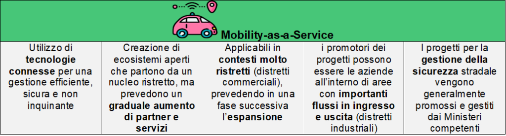
Figura 5 Temi chiave dell’ambito “Mobility-as-a-Service”. Fonte: elaborazione The European House – Ambrosetti su dati vari, 2022
Tra i 5 use case italiani, di particolare interesse è l’app per la mobilità dell’area metropolitana di Firenze sviluppata da Comune di Firenze e ATAF (Azienda Trasporti dell’Area Fiorentina). Questo progetto nasce con l’obiettivo di creare un’applicazione per consentire agli utenti di pianificare i viaggi in autobus e acquistare direttamente i biglietti tramite app. L’app consente inoltre di monitorare in tempo reale gli orari dei propri spostamenti grazie alla rilevazione in tempo reale della posizione dei mezzi. Ad oggi, l’app è utilizzata da oltre 600.000 cittadini residenti nel Comune di Firenze e 3,5 milioni di turisti, divenendo così il principale canale di comunicazione tra ATAF e gli utenti dei servizi di trasporto pubblico urbano con un tasso d’interazione che grazie ad essa è aumentato di 10 volte.[3]
Sul piano internazionale, invece, viene portata in evidenza la collaborazione tra attori Pubblici e Privati di Finlandia, Norvegia, Svezia e Danimarca per lo sviluppo di NordicWay. Si tratta di un progetto che mediante tecnologie di connettività V2X (Vehicle-to-Everything) permettere ai veicoli di comunicare tra loro e con l’infrastruttura stradale circostante al fine di ridurre i rischi alla guida nei mesi invernali. Il punto di partenza è stato l’ampliamento della connettività ad alta velocità lungo i tratti stradali interessati dalla sperimentazione. La fase successiva sarà volta a individuare use case e nuovi ambiti di lavoro da parte delle Autorità Cittadine, coinvolgendo nuovi partner privati, che consentiranno al sistema di comunicare il punto esatto di un incidente e mappare le aree a maggiore incidentalità. Nello sviluppo di NordicWay sono stati coinvolti 35 attori, tra Pubblici e Privati. Nei prossimi anni, NordicWay mira a creare un sistema connesso capace di rilevare segnaletica stradale, semafori, veicoli in stato di emergenza, pericoli e aree geografiche destinate a particolari forme di mobilità (ZTL, zone green, aree pedonali). Attualmente sono attivi 17 ambiti di sperimentazione per il miglioramento di sicurezza e connettività delle strade che nel 2030 comporteranno una diminuzione stimata del 6,3% di incidenti fatali.[4]
Nell’area “Mobilità connessa e gestione flotte” è stato individuato un solo caso italiano di Corporate Car Sharing e 48 casi a livello internazionale (il 32% del totale), principalmente nella categoria monitoraggio efficiente dei mezzi (14% – 21 casi). Dall’analisi di tutti i progetti, sono stati individuati 3 punti chiave, riassunti nella figura successiva.
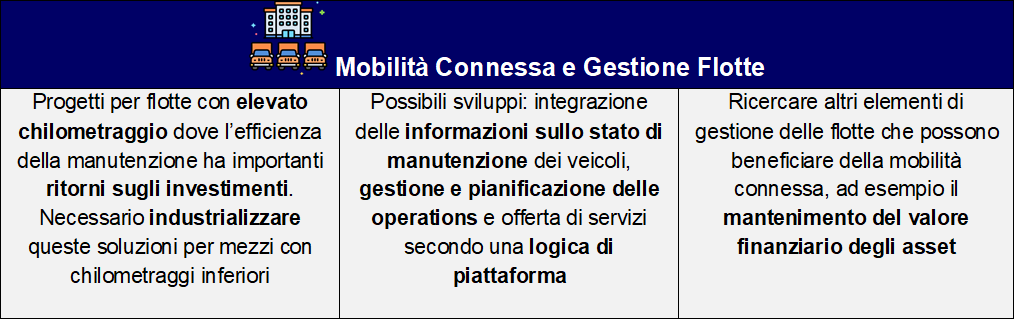
Figura 6 Temi chiave dell’ambito “Mobilità connessa e gestione flotte”. Fonte: elaborazione The European House – Ambrosetti su dati vari, 2022
Il caso italiano fa riferimento alla piattaforma di Corporate Car Sharing di Terna, nata per fornire uno strumento innovativo ed efficiente di gestione della flotta aziendale, che consenta al fleet manager di individuare il veicolo più adatto alle esigenze operative grazie a una dashboard di strumenti di controllo dei mezzi aziendali, a cui è associata una produzione di report diagnostici puntuale. I dipendenti possono utilizzare l’app T-Fleet per prenotare i veicoli aziendali (geolocalizzando il mezzo più vicino all’interno delle sedi operative) e richiedere assistenza (i servizi di supporto attivi sono attivi h24). Per la realizzazione di questo progetto, Terna ha introdotto 1.400 nuovi veicoli (mezzi speciali, auto, furgoni e fuoristrada), di cui 220 elettrici distribuiti in maniera capillare in 80 sedi in tutta Italia. Attualmente Terna ha coinvolto 150 dipendenti nella sperimentazione dell’app e del nuovo sistema di CCS.[5]
Un caso interessante di “manutenzione ottimizzata dei mezzi” è stato individuato in Portogallo, dove la Startup Stratio (leader nella manutenzione della flotta in real-time) ha sviluppato sistemi di artificial intelligence per ottimizzare gli interventi di manutenzione. L’obiettivo del progetto è analizzare in tempo reale lo stato del veicolo (autobus o altri mezzi pesanti) per fornire servizi di manutenzione predittiva, al fine di ridurre i tempi di fermo e i costi connessi a guasti non previsti, ma anche fornire ai gestori delle flotte una piattaforma facile da usare e ricca di informazioni ad alto valore per migliorare l’operatività quotidiana. Le flotte sono equipaggiate con sistemi IoT che permettono un monitoraggio real time dei dati raccolti dai mezzi, analizzati da un modello di predictive AI in grado di creare degli insight per ridurre i rischi di downtime e prevenire le rotture, suggerendo il momento ottimale per effettuare le operazioni di manutenzione. Le tecnologie di Stratio sono utilizzate in 5 tra le 10 compagnie di trasporto più importanti a livello mondiale per un totale di 1,3 miliardi di utenti e 5 miliardi di informazioni processate ogni giorno.[6]
L’ultima area strategica è “Ecosistemi e spazi dati per la co-creazione di servizi”: i temi della condivisione dei dati e la collaborazione tra i diversi attori della mobilità sono, di fatto, trasversali alle tre aree precedentemente illustrate. Ne consegue che le considerazioni afferenti a questa area strategica, e riportate nella figura successiva, sono di notevole importanza e devono essere considerate al fine di creare i presupposti abilitanti allo sviluppo dei futuri sistemi di mobilità. Nel dettaglio, sono stati individuati 4 use-case, 2 italiani e 2 a livello internazionale contraddistinti da una natura open source particolarmente accentuata.
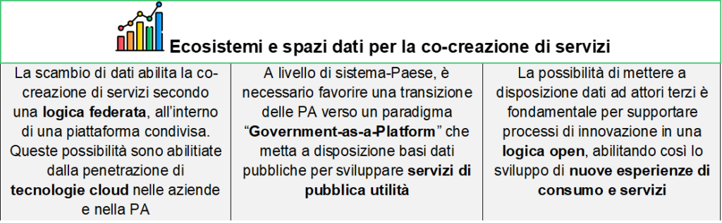
Figura 7 Temi chiave dell’ambito “Ecosistemi e spazi dati per la co-creazione di servizi”. Fonte: elaborazione The European House – Ambrosetti su dati vari, 2022
Un caso italiano molto interessante è C-Roads Italy 2, nato da un’iniziativa europea volta a stimolare la cooperazione tra attori Pubblici e Privati per testare e implementare “sistemi di trasporto intelligente cooperativi” (C-ITS) quali: avviso di velocità ottimale, richiesta di priorità della precedenza stradale da parte di veicoli designati, segnali di violazione di sicurezza degli incroci, informazioni sulla disponibilità di parcheggi pubblici e sulle condizioni del traffico. Per la realizzazione di questo progetto è stato necessario adattare le infrastrutture cittadine (a Torino, Trento e Verona): in totale, è stato eseguito un upgrade di 70 semafori e sono stati ammodernati diversi edifici (pubblici e privati) per installare gli strumenti di connettività C-ITS. Il progetto pilota C-Roads Italy 2 è iniziato nel 2018, terminerà nel 2023 e, ad oggi, ha previsto il coinvolgimento di 11 stakeholder nazionali.[7]
A livello internazionale, è risultato particolarmente rilevante il progetto “Transport for London Unified API”, nato con l’obiettivo di creare una piattaforma open source per raccogliere e scambiare dati di ogni mezzo di trasporto pubblico londinese in tempo reale. Sono stati creati oltre 11 database tematici alimentati in real-time con dati provenienti sia da infrastrutture cittadine sia con basi dati messe a disposizione da stakeholder privati ad esempio. La raccolta e la messa a disposizione di questi dati in logica open hanno permesso, ad oggi, di sviluppare oltre 650 applicazioni favorendo la creazione di un solido network di aziende innovative in ambito mobilità in grado di creare servizi a valore aggiunto per i cittadini, basti pensare che il 42% dei londinesi utilizza almeno una app basata sugli open data di Transport for London.[8]
Autore:
The European House – Ambrosetti
[1] Fonte: Rielaborazione The European House – Ambrosetti su dati Regione Piemonte e 5T, 2022.
[2] Fonte: Rielaborazione The European House – Ambrosetti su dati Roadefend, 2022.
[3] Fonte: Rielaborazione The European House – Ambrosetti su dati ATAF, 2022
[4] Fonte: Rielaborazione The European House – Ambrosetti su dati Nordicway 2 e Nordicway 3, 2022.
[5] Fonte: Rielaborazione The European House – Ambrosetti su dati Terna, 2022.
[6] Fonte: Rielaborazione The European House – Ambrosetti su dati Stratio, 2022.
[7] Fonte: Rielaborazione The European House – Ambrosetti su dati C-Roads Italy 2, 2022.
[8] Fonte: Rielaborazione The European House – Ambrosetti su dati Transport for London Unified API, 2022.
The reference pilots for the development of the “Italian way to connected mobility”: a mapping of more than 160 cases
During the development of the 2021 edition of the “Italian Way to Connected Mobility”, OCTO Telematics and The European House – Ambrosetti identified over 35 pilot projects, 14 of which have been considered as “quick win” priorities, i.e. initiatives implementable in a period of about 6 months. These pilot projects are aiming at the realization of OCTO’s Vision Zero and range within 4 strategic areas – “Smart and Connected mobility as enablers for the Smart City”, “Mobility-as-a-Service” (MaaS), “Connected mobility and fleet management” and “Ecosystems and data spaces for the co-creation of services”.
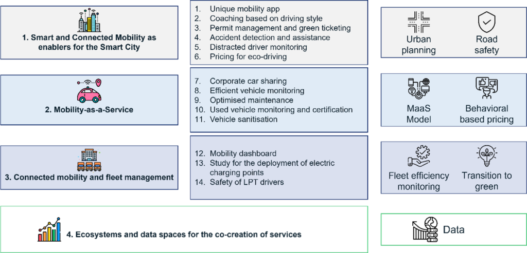
Figure 1 Breakdown of strategic areas by pilot projects and macro-contents. Source: elaboration by The European House – Ambrosetti and OCTO Telematics, 2022
Now, the 2022 edition of this program has been launched under the main goal of materializing those pilot projects by establishing meaningful relationships between different key stakeholders so to promote the birth of a strong ecosystem on connected mobility.
Under such premises, this first article aims to provide an overview of the most relevant case studies in the Italian and global context, with a threefold purpose:
- create a benchmark – on the development of projects related to connected mobility in order to draw inspiration from the best national and international practices characterised by significant elements of innovation and/or the ability to involve multiple stakeholders;
- Understand the specifics and key standpoints related to each strategic area;
- Identify market gaps, such as less implemented pilot projects or new cities where there are opportunities to intervene.
Thanks to an intense research activity, 160 cases have been mapped, of which 92 in Europe (10 in Italy), 24 in the USA and 13 in China.

Figure 1 Thematic distribution of the case studies mapped in Italy (left image) and internationally (right image), absolute value and percentage, 2022. Source: elaboration by The European House – Ambrosetti, 2022
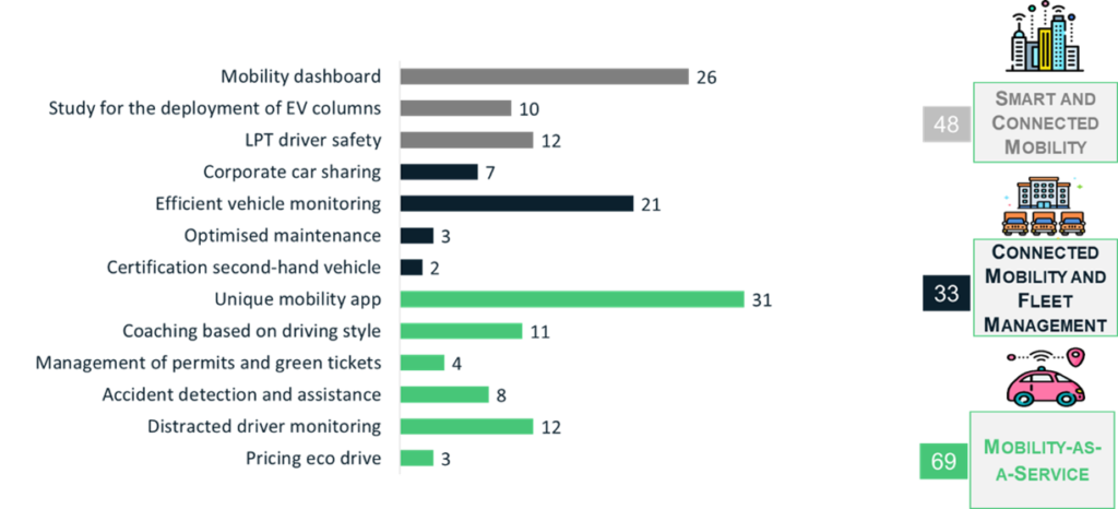
Figure 2 Total number of internatonal case studies analyzed by pilot project, absolute value, 2022. Source: elaboration by The European House – Ambrosetti, 2022
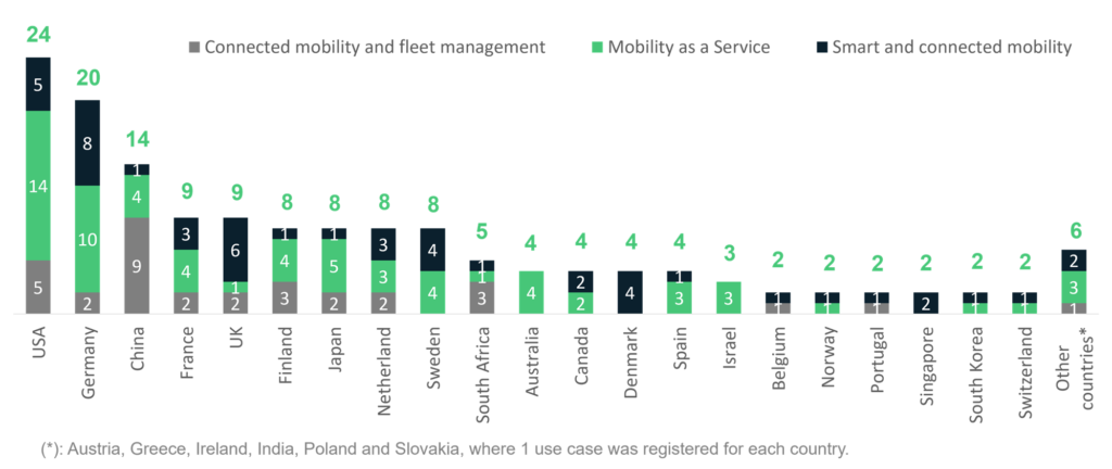
Figure3 Geographical distribution of case studies mapped at international level absolute value, 2022. Source: elaboration by The European House – Ambrosetti, 2022
As far as the “Smart and Connected Mobility” area is concerned, the research identified 2 “Mobility Dashboard” projects in Italy and 33 on a global scale, numbering a 22% of the total use cases mapped, meaning that “Mobility Dashboard” pilots are the most widespread (17.3% – 26 cases) both within the Italian context, and at the international level the. The key points emerged are summarized in the figure below.
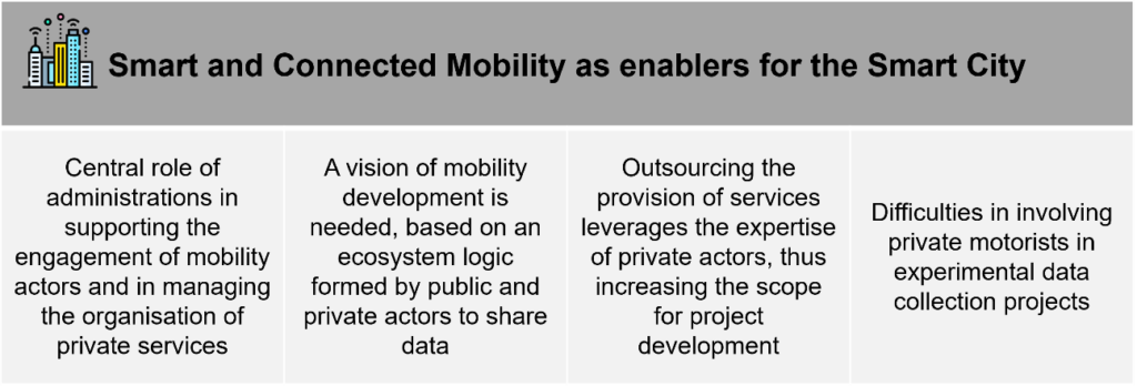
Figure 4 Key themes within the scope of “Smart and Connected Mobility as enablers for the Smart City”. Source: elaboration by The European House – Ambrosetti on various data, 2022
To have a better reference regarding the implementation of pilot projects in this area, one Italian and one international case have been reported below.
As far as the Italian context is concerned, 5T Torino is an in-house company with a 100% public participation operating in the design, implementation and management of systems and services for the Mobility and Infomobility Central of Turin and Piedmont. The main objective of 5T Torino is to create new service models and technological paradigms to respond to the evolving needs of users. Specifically for the creation of Turin and Piedmont Mobility Centers and MaaS systems an ecosystem has been developed, using digital technologies and IoT systems integrated into existing and new city infrastructures. To date, 300 intersections have been “centralized” to control traffic, 1,000 sensors have been installed to measure traffic flows, 71 monitoring cameras, 43 entry gates within the ZTL and 25 infotraffic panels have been installed. [1]
Within the international context, an interesting example of “Safety of LPT drivers” has emerged, realized by the Chinese Roadefend Vision Technology (a company specialized in ADAS systems and connected Big Data management) in partnership with Alibaba. The project was created to increase the safety of drivers thanks to active safety systems (cameras, sensors) installed on board, able to store in the cloud theinformation collected to feed artificial intelligence algorithms able to generate warning signals in case of risk. The Roadefend solution leverages advanced high-resolution image analysis technology for “external” (e.g., weather conditions and proximity to other vehicles/obstacles) and “internal” (e.g., driver facial expressions to detect signs of distraction or fatigue) monitoring. In addition, a cloud platform has been created, in which real-time driving data collected via GPS are displayed in a continuously updated dashboard. To date, Roadefend devices have been installed in 290 million vehicles that have covered a total of 3 billion km.[2]
Regarding projects for the promotion of “Mobility-as-a-Service”, in Italy there have been identified the following key use cases:
- 2 use cases of “Single mobility app”,
- 2 of “Management of permits and green tickets”
- 1 case of “Pricing for eco-driving” were mapped.
On a global scale, 69 projects were identified (46% of the total), of which 31 are Mobility Apps, which is the most implemented pilot and alone represents 20.6% of the total cases. From the analysis of all projects, 5 recurring themes were identified and are summarized in the figure below.
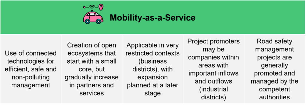
Figure 5 Key themes of the “Mobility-as-a-Service” area. Source: elaboration by The European House – Ambrosetti on various data, 2022
Among the 5 relevant Italian use cases, the most interesting one is the mobility app for the Florence metropolitan area developed by the Municipality of Florence and ATAF (Azienda Trasporti dell’Area Fiorentina). This project was created with the objective of creating an application to allow users to plan bus trips and purchase tickets directly through the app. The app also allows users to monitor their travel schedules in real time thanks to the real-time detection of the position of the vehicles. To date, the app is used by more than 600,000 citizens residing in the City of Florence and 3.5 million tourists, thus becoming the main channel of communication between ATAF and the users of urban public transport services with an interaction rate that has increased 10 times thanks to it. [3]
On the other hand, the collaboration between public and private players in Finland, Norway, Sweden and Denmark for the development of NordicWay represents the most interesting use case on an international level. This is a project that uses V2X (Vehicle-to-Everything) connectivity technologies to allow vehicles to communicate with each other and with the surrounding road infrastructure in order to reduce driving risks during the winter months. The starting point was the expansion of high-speed connectivity along the road sections involved in the experimentation. The next phase will be aimed at identifying use cases and new areas of work by the City Authorities, involving new private partners, which will allow the system to communicate the exact point of an accident and map the areas with the highest accident rate. In the development of NordicWay, 35 Public and Private actors have been involved. In the coming years, NordicWay aims to create a connected system capable of detecting road signs, traffic lights, vehicles in an emergency state, hazards and geographical areas intended for particular forms of mobility (ZTL, green zones, pedestrian areas). There are currently 17 active areas of experimentation for the improvement of safety and connectivity of roads that will result in an estimated decrease of 6.3% of fatal accidents in 2030.[4]
In the area “Connected mobility and fleet management”, only one Italian case of Corporate Car Sharing amongst 48 other cases at international level (32% of the total) have been identified, mostly within the category of efficient vehicle monitoring (14% – 21 cases). From the analysis of all the projects, 3 key points were identified, summarized in the figure below.
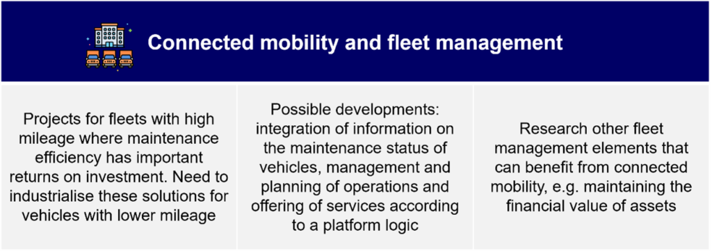
Figure 6 Key themes of the “Connected mobility and fleet management” area. Source: elaboration by The European House – Ambrosetti on various data, 2022
The Italian case refers to Terna’s Corporate Car Sharing platform, which was created to provide an innovative and efficient tool for managing the company’s fleet, enabling the fleet manager to identify the most suitable vehicle for operational needs thanks to a dashboard of tools for controlling company vehicles, which is associated with the production of timely diagnostic reports. Employees can use the T-Fleet app to book company vehicles (by geolocating the nearest vehicle within the operational sites) and request assistance (active support services are available 24 hours a day). To implement this project, Terna has introduced 1,400 new vehicles (special vehicles, cars, vans and off-road vehicles), 220 of which are electric vehicles distributed throughout 80 sites throughout Italy. To date, Terna has involved 150 employees in testing the app and the new CCS system.[5]
An interesting case of “optimized vehicle maintenance” has been identified in Portugal, where startup Stratio (a leader in real-time fleet maintenance) has developed artificial intelligence systems to optimize maintenance interventions. The goal of the project is to analyze the real-time status of the vehicle (bus or other heavy equipment) to provide predictive maintenance services, thusreducing downtime and costs related to unplanned breakdowns, and providing fleet managers with an easy-to-use platform rich in high-value information to improve daily operations. Fleets are equipped with IoT systems that enable real-time monitoring of data collected from vehicles, analyzed by a predictive AI model that can create insights to reduce downtime risks and prevent breakdowns by suggesting the optimal time to perform maintenance operations. Stratio’s technologies are used in 5 of the top 10 transportation companies worldwide with a total of 1.3 billion users and 5 billion pieces of information processed every day.[6]
The last strategic area is “Ecosystems and data spaces for the co-creation of services”: the themes of data sharing and collaboration between the various mobility players are, in fact, transversal to the three areas previously illustrated. It follows that the considerations relating to this strategic area, and reported in the next figure, are of considerable importance and must be considered to create the enabling conditions for the development of future mobility systems.
In detail, 4 use-cases have been identified: 2 Italian projects and 2 international ones, all characterized by a particularly pronounced open source nature.
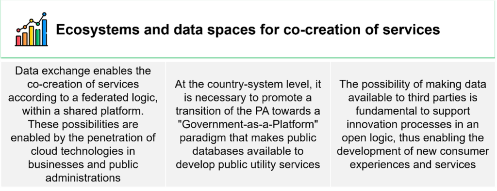
Figure 7 Key themes of the scope “Ecosystems and data spaces for the co-creation of services”. Source: elaboration by The European House – Ambrosetti on various data, 2022
A very interesting Italian case is C-Roads Italy 2, born from a European initiative aimed at stimulating cooperation between Public and Private actors to test and implement “cooperative intelligent transport systems” (C-ITS) such as: optimal speed warning, priority request for road priority by designated vehicles, intersection safety violation signals, information on availability of public parking and traffic conditions. For the realization of this project, it was necessary to adapt city infrastructures (in Turin, Trento and Verona): in total, 70 traffic lights were upgraded and several buildings (public and private) were modernized to install C-ITS connectivity tools. The C-Roads Italy 2 pilot project started in 2018, will end in 2023 and, to date, has included the involvement of 11 national stakeholders.[7]
At the international level, the “Transport for London Unified API” project was deemed particularly relevant. Created with the aim of establishing an open-source platform to collect and exchange data from every means of public transport in London in real time, “Transport for London Unified API” is the result of more than 11 thematic databases that are constantly fed in real time with data coming both from city infrastructures and from databases made available by private stakeholders. The gathering and displaying of these data in an open logic have allowed, to date, the development of over 650 applications, favouring the creation of a solid network of innovative companies in the field of mobility able to create value-added services for citizens: as a result, 42% of Londoners use at least one app based on Transport for London’s open data.[8]
Author:
The European House – Ambrosetti
[1] Source: Re-elaboration by The European House – Ambrosetti on data from Piedmont Region and 5T, 2022.
[2] Source: Re-elaboration by The European House – Ambrosetti on data from Roadfend, 2022.
[3] Source: Re-elaboration by The European House – Ambrosetti on ATAF data, 2022.
[4] Source: Re-elaboration by The European House – Ambrosetti on Nordicway 2 and Nordicway 3 data, 2022.
[5] Source: Re-elaboration by The European House – Ambrosetti on Terna data, 2022.
[6] Source: Re-elaboration by The European House – Ambrosetti on Stratio data, 2022.
[7] Source: Re-elaboration by The European House – Ambrosetti on data from C-Roads Italy 2, 2022.
[8] Source: Re-elaboration by The European House – Ambrosetti on Transport for London Unified API data, 2022.